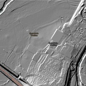
Vici.org
No images available yet. Please add images related to this place.

Surroundings:

Map of earthworks at Maes Knoll, SomersetMaes KnollIron Age hill fort at Ham HillStantonbury CampCadbury's Factory

Location:

  • United Kingdom of Great Britain and Northern Ireland, Stanton Drew
  • geo:51.365456,-2.579496
  • Location ± 0-5 m.

Period or year:

  • -4000~ / -3000~

Class:

  • Relief, votiv stone or altar
  • visible

Identifiers:

  • vici:place=60520

Annotations


Nearby

Stanton Drew Southwest Circle

Stanton Drew stone circles.

Stanton Drew Great Circle

Stanton Drew stone circles.

Stanton Drew Northeast Circle

Stanton Drew stone circles. Neolithic.


This object was added by Elżbieta on 2019-02-25. Last update by Elżbieta on 2019-02-25. Persistent URI: http://vici.org/vici/60520 . Download as RDF/XML, GeoJSON, KML.
Annotation available using the Creative Commons Attribution-ShareAlike 3.0 Unported license. Metadata available using the Creative Commons Public Domain Dedication, unless it is explicitly stated otherwise.

Vici.org partners:

Livius.org: articles on ancient history   Rijksmuseum van Oudheden