
Elegeia or Elegia was a Roman military camp and fort near the frontier between Cappadocia and Armenia, located on the northeastern edge of Ilıca, now part of Aziziye, west of Karen/Theodosioupolis (Erzurum). The site hosted the emperor Trajan and the Parthian prince Parthamasiris during the Roman campaign in Armenia in 114, and was associated with a subsequent Roman reverse in 162.
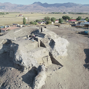
Little visible remains, now largely effaced by modern agriculture. The smaller western rectangular enclosure of the Roman fort is still visible amid the fields, now with a lonely tree growing within it, but the larger rectangular enclosure immediately to its east has been almost completely effaced, compared to satellite imagery from 2005.
Kai Juntunen, “Ancient Elegeia – Battlefield or Roman outpost? From written sources to archaeological evidence”, in N. Mrđić et al. (eds.), Limes XXIIII. Proceedings of the 24th International Congress of Roman Frontier Studies, Serbia 2018, vol. 1, Belgrade, 2023: 393-401.

Localisation:
- Turquie, Ilıca
- geo:39.94722,41.119968
- Précision ± 0-5 m.
Period or year:
- ante 114 / unknown
Classification:
- Camp fortifié
- Visible
Identificateurs:
- vici:place=103350
Annotations
Elegeia or Elegia was a Roman military camp and fort near the frontier between Cappadocia and Armenia, located on the northeastern edge of Ilıca, now part of Aziziye, west of Karen/Theodosioupolis (Erzurum). The site hosted the emperor Trajan and the Parthian prince Parthamasiris during the Roman campaign in Armenia in 114, and was associated with a subsequent Roman reverse in 162.
Little visible remains, now largely effaced by modern agriculture. The smaller western rectangular enclosure of the Roman fort is still visible amid the fields, now with a lonely tree growing within it, but the larger rectangular enclosure immediately to its east has been almost completely effaced, compared to satellite imagery from 2005.
Kai Juntunen, “Ancient Elegeia – Battlefield or Roman outpost? From written sources to archaeological evidence”, in N. Mrđić et al. (eds.), Limes XXIIII. Proceedings of the 24th International Congress of Roman Frontier Studies, Serbia 2018, vol. 1, Belgrade, 2023: 393-401.
À proximité
Calcidava (1 km)
OmnesViae import TPPlace2481
Roman Rd (3 km)
Roman Rd
Ҫobandede Koprusu (3 km)
Roman Bridge