Es gibt noch keine deutschsprachige Anmerkungen. Präsentiert wirden Anmerkungen auf Französisch.
Place to remove, this is not the exact location of the antic village Alaunium, already present on the map 2km on the south

Place to remove, this is not the exact location of the antic village Alaunium, already present on the map 2km on the south
Place to remove, this is not the exact location of the antic village Alaunium, already present on the map 2km on the south
Notre-Dame des Anges
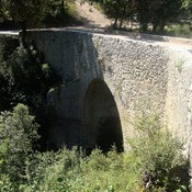
Römerbrücke - Ganagobie
Bourne de Tavernoure, possible Roman boundary marker