
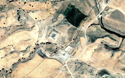

Sassanian (?) and medieval Islamic settlement (5 ha). Visible rectangular central tell (70x100m), previously surrounded by an eastern sharistan and smaller mounds, destroyed between 2002 and 2011. Emāmzāde built on top of the main mound. Possible identification with the medieval town of Hir (Kitab al-masalik wa-I-mamalik of Eṣṭakhrī) / Habs (Fārsnāma of Ibn al-Balkhi), described as one the stage of the main road between Shiraz and Arrajan. Also possible identification with the site of Ḥājī ʿAlī visited by A. Stein (Old Routes of Western Iran, 1940), described as a once occupied place in medieval times near an emāmzāde.
LE STRANGE G. & NICHOLSON R.A. (1921), The Fars-nama of Ibn u’l Balkhi (text in persian) (https://archive.org/details/frsnmaofibnu00ibnauoft/mode/2up )
AL-ISTAKHRI (Xe s.), Masalik al-mamalik - Livre des Routes et des Royaumes, ed. DE GOEJE M. J. (1927), Bibliotheca Geographorum Arabicorum, Vol.1, 2ed (en pers.) (https://archive.org/details/india.history.resource.91285/mode/2up )
LE STRANGE Guy (1905), the lands of the eastern caliphate - from the Moslem Conquest to the time of Timur, Cambridge Press (https://archive.org/details/landsofeasternca00lest )
STEIN Aurel (1940), Old Routes of Western Iran (https://library.hungaricana.hu/en/view/MTAKonyvtarKiadvanyai_BORB_02/?pg=116&layout=s )